
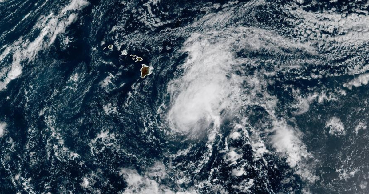
Tropical Storm Moke is not forecast to make a direct hit on Hawaii in the supplied reports, but it can still create dangerous conditions. As of the Hawaii Emergency Management Agency update published August 22, 2026, the storm was moving west-northwest and was expected to pass south of the Big Island. The agency said heavy rainfall and gusty winds were expected to begin that night, while no coastal watches or warnings were in effect at the time.
The practical decision for residents and visitors is to prepare for rain-related disruption rather than assume that a track south of the islands means no risk. CBS News, citing the National Hurricane Center, reported projected rainfall of 5 to 10 inches on the Big Island, with totals as high as 15 inches in some locations. Those figures are forecasts, not measurements, and the official state page supplied here does not provide a comparable rainfall total.
What is confirmed about Tropical Storm Moke?
The state report placed Moke near latitude 14.9 North and longitude 151.1 West at 11 a.m. Hawaii Standard Time on August 22. It described the storm as moving west-northwest near 12 miles per hour and said that general motion was expected to continue for several days. CBS News described the system later that day as having maximum sustained winds of 45 miles per hour and moving west at 14 miles per hour.
The difference in movement descriptions is not, by itself, evidence of a major track change. The reports were issued at different times and used different directional wording. The consistent point is that Moke was south of the Hawaiian Islands and that its center was forecast to pass south of the Big Island before moving farther south of the smaller islands.
Why can a storm passing south still cause serious problems?
Rainfall is the main concern identified in the evidence. CBS News reported that the National Hurricane Center expected the windward and southeast Big Island to face the greatest flooding and mudslide risk, particularly in steep terrain and places recently affected by Hurricane Lala. The reason is straightforward: intense rain can overwhelm drainage, destabilize slopes and push water across roads even when a storm’s center stays offshore.
Recent damage changes the threshold for disruption. CBS News reported that the Big Island and other parts of Hawaii had been hit hard by Lala the previous weekend, including areas with severe rain and wind. Maui County Mayor Richard Bissen said communities were still recovering and that even light to moderate rain and wind could contribute to flooding, debris, downed trees, roadway problems and power outages.
That does not mean every location will experience those outcomes. It does mean the same forecast can carry different consequences depending on terrain, drainage, existing debris and the condition of roads and utilities. A visitor in a low-risk urban area may mainly face canceled plans or travel delays; someone near steep terrain, a stream, a damaged road or a recently flooded area may face a more serious access and safety problem.
What remains unknown about the storm?
The supplied reports do not explain why Moke formed, so any claim about its cause would go beyond the evidence. They also do not establish a final track, exact rainfall totals for individual communities or whether the storm will strengthen before passing south of Hawaii.
CBS News reported that little change in strength was expected on August 22, followed by likely weakening beginning Sunday. That is a forecast, not a confirmed outcome. Conditions can change as new advisories incorporate updated observations and model guidance.
What should people watch before making plans?
Residents and visitors should check updated National Hurricane Center forecasts and local emergency-management notices rather than rely on the storm’s current position alone. The most useful signals are changes to the projected track, rainfall amounts, wind expectations and the issuance of watches or warnings.
People deciding whether to travel, drive through vulnerable areas or remain in place should weigh access and recovery conditions, not just wind speed. Avoiding steep or flood-prone routes may carry a cost in time or convenience, but recent storm damage can make a familiar route less reliable. The evidence supports preparation for heavy rain and gusty winds; it does not support assuming a direct landfall or a uniform island-wide impact.
The next clear milestone will be the emergency-management and hurricane-center updates issued as Moke approaches the islands. Those updates can confirm whether the south-of-the-Big-Island track holds and whether local rainfall or flooding guidance needs to change.
Tropical Storm Moke's immediate significance is less about a forecast landfall than about how rain interacts with recently damaged terrain and infrastructure. The strongest supported conclusion is that the storm was expected to pass south of the Big Island while bringing heavy rain and gusty winds. CBS News reported rainfall of 5 to 10 inches on the Big Island, with up to 15 inches in some locations, but those remain forecasts. The evidence does not establish Moke's cause, final strength or exact local effects. Readers should use updated hurricane-center and emergency-management guidance to judge travel, road and flood exposure.
Sources and methodology
- tropical storm moke - https://dod.hawaii.gov/hiema/tropical-storm-moke
- Tropical Storm Moke expected to bring up to 15 inches of rain in Hawaii - https://www.cbsnews.com/news/tropical-storm-moke-rain-hawaii-big-island